

The KV - Self Service - Belmaig
FOLLOWING THE ANNOUNCEMENT OF THE CONTAINMENT, registrations remain open: A date will be announced after the Deconfinement! >> We will manage to complete this edition!

Time yourself!
The Belmaig Vertical Kilometer route
Version 3.0 "Self-Service"
This solution makes it possible to align with the route and to take
a course open all day!
Possibility to line up and time yourself.
The route starts at the Fontaine des Buis d'Arles sur Tech and ends
at the top of Pilon du Belmaig.
Up there => A superb 360 ° view of the Canigou Massif,
the Vallespir, Northern Catalonia and the bay of Rosas
as well as the Mediterranean on the French side.
Thanks to the Timing App,
You will be able to live a
unique experience by participating
and by taking SOLO a route, previously run in competition, and also
to go there whenever you want
With the App, a stopwatch will allow you to assess yourself and
to live a new sporting experience,
by following the COVID recommendations and restriction .
The application after registration will allow you to Flash the QR Codes listed on the route and validate your route.
By being registered, you access the Endowment Pack
Tee-Shirt - Diploma & Snack


OPERATION:
To begin with, it is necessary
to download for free
the IORENTEERING application
and create a quick account
thanks to QRCodes (opposite).
From there it only remains to scan
from this application the QR code which is on the information panel on site, at the start of the course.
Then we start to climb!
We then follow the uphill path that leads us to the top, where the Final sign is located, where we have to scan using the app the arrival QR code which stops the stopwatch at the end of the route.
The stopwatch is indicated on the application, the overall ranking of participants is updated by the organization below.


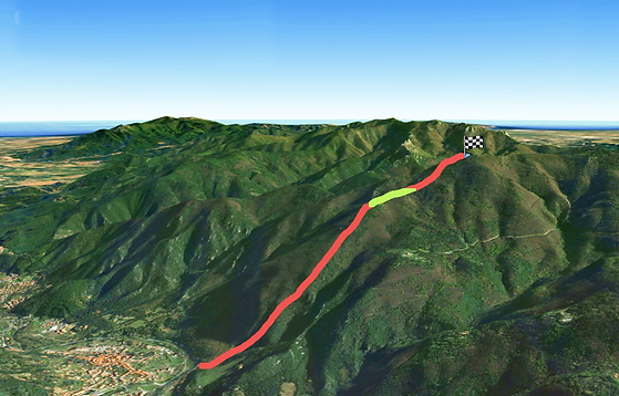
COURSE
Vertical Kilometer
The course with a length of
2.9 km for 1000m of vertical drop
positive to reach the top
of Belmaig.
A course that has the capacity for the best runners to beat the Belmaig ascent record?
The first track (4.8km) was considered too rolling to be able to establish a record performance.
The route starting from the boxwood fountain takes a steep path in the chestnut forest. at km 1.8, the horizon clears, the Belmaig is 1.1 km further.
The steep sections continue to follow one another up to the top.
GPS track to download


Endowment registered
REGISTRATION
Registrations are only made online, due to the health situation related to COVID19.
Registration entitles everyone to: a Textile endowment PACK, participation certificate & snack - the marking of a course over two days.
In addition to this, you need to know more about it.
In addition and if he wishes, the registrant has the possibility under his own responsibility to take a route and use an application made available to him, through his own smartphone.
In addition to this, you need to know more about it.
A permanence during these two days, at the start of the course (Fontaine des Buis) will allow registrants to withdraw their prize pack.


